Imagine this: You’re on the rooftop, enjoying your morning coffee and feeling the sun on your skin. You’re listening to the waves crashing in the distance, and scrolling through your phone to check the surf forecast. But wait… what exactly are all these numbers and symbols? If you’re new to reading surf forecasts, it can seem a little confusing. But don’t worry, it’s actually pretty simple once you know what to look for. Today, we’re going to break it down step by step and help you understand each component. By the end, you’ll be reading a surf forecast like a pro and knowing exactly when to hit the waves!


Components of a Surf Forecast
When you open up a surf forecast, you’re going to see several pieces of information. Each one plays a role in telling you what the waves will be like. Let’s go over the key elements:
1. Wave Height
This one is pretty straightforward. Wave height refers to the vertical height of the wave, usually measured in meters or feet. A higher number means bigger waves. For example, a forecast showing wave heights around 1.5 meters means there’s going to be some decent swell. If you’re looking for bigger thrills, 2-3 meters would be the sweet spot. However, for beginners, smaller waves, around 0.5 to 1 meter, are much easier to practice on.
Wave height is influenced by a number of factors, including wind strength and the size of the swell (more on that next!). It’s a crucial piece of information to keep in mind.
2. Swell Direction
The swell direction tells you where the waves are coming from. In a forecast, you’ll often see compass points like “WNW” (West-Northwest) or “SE” (Southeast). Understanding swell direction is important because certain beaches are better for certain swells.
For example, a surf spot facing west will work best with a west or northwest swell, because the waves will be coming straight toward the shore. At Devil’s Rock in Tamraght, a spot popular, you’ll often see swell directions from WNW, which makes it a great location for catching clean, consistent waves.
3. Swell Period
The swell period is how much time passes between two consecutive waves, measured in seconds. The longer the swell period, the more powerful the waves will be. For example, a 5-second period means that the waves will be choppy and close together, but a 12-second period or more indicates smoother, stronger waves that have traveled longer distances.
In the forecast for Devil’s Rock, you’ll notice periods around 12 to 14 seconds, which usually means well-formed waves. A 20-second period, as seen on some days, signals large, powerful waves—the kind that get surfers excited!
4. Wind Speed and Direction
Wind plays a massive role in how the waves will behave. Onshore winds (winds blowing from the sea toward the shore) tend to make the surf messy and unpredictable. Offshore winds (winds blowing from the land to the sea) do the opposite: they groom the waves, making them smoother and more surfable.
For example, in a surf forecast, you might see something like “WNW 15 km/h,” meaning the wind is coming from the west-northwest at a speed of 15 kilometers per hour. For ideal surfing conditions, you want light offshore winds—like “5 km/h NE,” where NE means the wind is blowing from the northeast, gently pushing the waves into better shape.
5. Tide Information
The tide can dramatically change the size and quality of the waves. Most surf forecasts include details on high tide and low tide, along with the time and height of each tide.
At Devil’s Rock, the surf often performs best at mid-to-high tide when the waves are more powerful. If you surf during low tide, the waves may be smaller and break too quickly.
How to read a surf forecast: Example for Devil’s Rock, Tamraght, Morocco
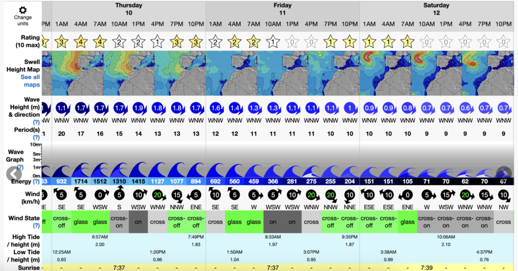
Let’s take a look at an actual surf forecast for Devil’s Rock:

- Wave Height: Ranges from 0.7 meters to 1.9 meters over the coming week, with the highest waves on Friday and Saturday.
- Swell Direction: Predominantly WNW (West-Northwest), perfect for this surf spot as it faces the right direction to catch these waves.
- Swell Period: Between 10 and 22 seconds, which means you’ll get a mix of more powerful sets and some smaller waves.
- Wind: Wind speeds range from 0 to 20 km/h, mostly WNW and NNW. On days with lighter winds, especially when they’re offshore, the waves will be cleaner.
- Tides: You’ll see high tides peaking in the early mornings and evenings, while low tides come around mid-day. Aim to surf during the rising or high tides for the best conditions.
By reading this forecast, we can tell that Thursday to Sunday will likely offer the best surf conditions, with larger waves (up to 1.9 meters) and a decent swell period of 15-20 seconds. Winds are moderate and offshore at times, meaning clean and fun waves.
Conclusion
Feeling more confident in reading a surf forecast? Now that you know what all the numbers mean, you can easily check the conditions before your next surf session. Whether you’re a beginner or a seasoned surfer, understanding the forecast will help you choose the perfect day to hit the water.
And hey, if this has got you in the mood for some surfing, why not join us at Let Us Surf? No matter your level, we cater to everyone—from absolute beginners to surf pros. Plus, we’ve got a cozy spot for you here in Tamraght, and some surf books to read while you wait for the next great set! See you in the water! 🌊
